
Travel Advisory For Tuesday and Wednesday As Rain May Cause Flash Floods
The New York City Emergency Management Department has issued a Travel Advisory for Tuesday, August 6 into Wednesday, August 7. The National Weather Service has issued a citywide Flood Watch in effect from 2:00 p.m. tomorrow Tuesday to 12:00 p.m. Wednesday.
According to the latest forecast, a frontal boundary will move through the metro area beginning tomorrow and will stall in the region into Wednesday. A few isolated showers and thunderstorms may produce briefly heavy rainfall and minor flooding as early as tomorrow morning with storms increasing in coverage by the afternoon. More widespread showers and thunderstorms may develop over the city overnight into Wednesday morning, with the potential for continued storm activity during the day Wednesday. As of right now, the worst of the impacts are anticipated tomorrow evening and overnight into early Wednesday morning.
“New Yorkers should prepare in advance of the storms and take the necessary precautions to remain safe,” said New York City Mayor Eric Adams. “While we expect some disruptions from this weather, all relevant city agencies have been activated and are prepared to handle whatever comes our way. New Yorkers, do your part: stay informed, stay alert, and, if you can, stay put during the worst of it. Sign up for Notify NYC and listen to the experts. New Yorkers are resilient, resourceful, and we look out for each other. That’s what will get us through this storm and any others that come our way.”
“New York City is bracing for heavy rain and possible flash flooding tomorrow into Wednesday,” said NYC Emergency Management Commissioner Zach Iscol. “New Yorkers should prepare for potential weather impacts that could disrupt travel, especially during the commute. We have activated a comprehensive response plan with our city agencies and utility partners to ensure the safety and well-being of all New Yorkers. I urge everyone to stay informed about changing weather conditions and potential travel delays through Notify NYC. Please also take a moment to check on your loved ones, particularly those who might need extra assistance during this time.”
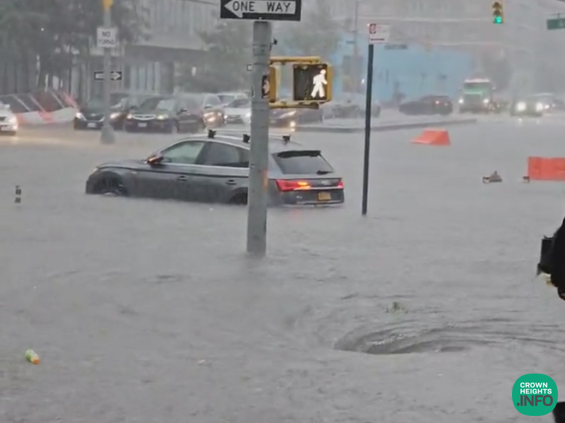
The magnitude and location of heavy rain and flooding remains uncertain. Currently, the NWS predicts the heaviest rain to occur to the southwest of the city. The latest forecast calls for 1 to 2 inches of rain with locally higher amounts possible. Increased amounts will be possible if the boundary stalls directly over the city.
In terms of impacts, flash flooding of roadways and properties may occur quickly, particularly in low-lying and poor drainage areas. Underground infrastructure, including basements, may also experience flooding. While much of the flooding is expected to be localized, more extensive flooding will be possible depending on where the boundary stalls. Travel delays and disruptions will also be possible during both the evening commute tomorrow and again Wednesday morning. In addition, there’s a low chance for severe thunderstorms tomorrow afternoon and evening producing sudden strong to damaging wind gusts of 50 to 60 mph, which may blow down trees and cause localized power outages.
New Yorkers are strongly urged to subscribe to emergency weather alerts on Notify NYC, which amplifies all National Weather Service advisories, watches and warnings in 14 languages including American Sign Language, and to stay informed about weather conditions from trusted sources. NYCEM encourages New Yorkers in the next few days to exercise caution when traveling, expect travel delays, and to remain off the roads during and after active weather to allow crews to operate and respond to weather conditions.
In preparation for the forecasted weather conditions, NYC Emergency Management has activated the City’s Flash Flood Emergency Plan. This proactive measure includes enhanced coordination with the National Weather Service, city and state agencies, utility providers, and private sector partners. Coordinated interagency calls are being organized to brief partners on emerging risks, review operational plans for potential severe weather, and to prepare them for possible escalation in their own response measures. Specialized emergency assets and response teams are on standby, ready for rapid deployment as conditions warrant.
The City’s Emergency Operations Center, already active due to the ongoing asylum seeker humanitarian crisis, has enhanced its posture to address the potential weather hazards. Crews from the Department of Environmental Protection and the Department of Transportation are actively inspecting and clearing catch basins in flood-prone areas. Additionally, NYC Emergency Management’s 24/7 Watch Command continues to track the progress and development of any further systems forming in the Atlantic basin on a 24/7 basis.
NYCEM strongly advises all residents, particularly those in flood-prone areas and basement apartments, to take immediate steps to prepare for the approaching storm and future weather event, starting with prioritizing their safety by staying alert and informed by monitoring the latest forecasts and updates from NYC Emergency Management, create a plan to ensure safety during a storm, and prepare a Go Bag with essential supplies like food, water, first aid, and other necessities.