Travel Advisory Issued For NYC With Snow and Freezing Rain Expected Tonight
The New York City Emergency Management Department has placed the city under a Travel Advisory due to expected snow and possible freezing precipitation tonight into tomorrow. The National Weather Service has issued a Winter Weather Advisory in effect citywide from 8 p.m. Monday, January 15, until 1 p.m. Tuesday, January 16, 2024. The latest NWS forecast calls for light snow to begin as early as 8 p.m. tonight, becoming increasingly steadier and heavier overnight. Accumulations of 2 to 3 inches are expected by daybreak tomorrow, likely resulting in slippery roads for the morning commute. The northern portions of the city could see as much as 4 inches of snow. New Yorkers should anticipate and plan for at least minor travel delays, with difficult travel in some instances.
The bulk of the snow is expected to end by mid-morning with light precipitation continuing through the early afternoon. A mix of snow, sleet, and freezing rain or drizzle will be possible during this time. Freezing precipitation may result in an instant layer of ice, particularly on non-snow-covered or exposed roadways that are untreated and/or elevated, such as bridges. Pedestrian walkways can also be immediately affected by freezing precipitation. Even though icy conditions will likely be patchy and not blanket the entire city, New Yorkers are urged to be very mindful of this threat, not only while driving, but also to avoid slips and falls. The most likely window for freezing precipitation is between about 10 a.m. and 1 p.m. on Tuesday.
There may be a quick changeover back to light snow in the early afternoon before all precipitation comes to an end sometime between 2 p.m. and 4 p.m. Significant impacts are not anticipated for the evening commute at this time, although residual snow and ice could again result in a few travel delays. Outside of any freezing precipitation, there will also be a chance for any melted snow or standing water to re-freeze later in the evening. Temperatures during the day are predicted to nose above freezing, particularly closer to the coast. Alongside the rain, this would allow for some melting, which may then re-freeze as temperatures drop after sunset. Abundant sunshine during the day Wednesday could result in another melt/re-freeze cycle with patchy ice possible in the evening.
A cold airmass settles into the region following the storm. Temperatures are forecast to be several degrees below the norm throughout the week with lows in the low 20s and wind chills in the teens to single digits. This will be the city’s longest and coldest outbreak of the season thus far. A second storm late this week could bring another round of snow and an even colder air over the weekend, with wind chills potentially nearing zero alongside gusty winds. Temperatures may not rise above freezing until next Monday, resulting in the possibility of frozen or burst pipes.
“With snowfall projected to hit our area this evening into tomorrow morning, New Yorkers should take the necessary precautions to remain safe,” said New York City Mayor Eric Adams. “While it’s been nearly two years since New York City experienced more than an inch of snowfall, all relevant city agencies have been activated and are prepared to handle whatever comes our way. As a reminder, New Yorkers should sign up for Notify NYC to keep up to date on winter weather.”
“New Yorkers should prepare for hazardous travel conditions tonight and tomorrow,” said NYC Emergency Management Commissioner Zach Iscol. “With cold temperatures and steadily accumulating snowfall overnight, there’s a good chance for slick snow-covered roadways and travel delays during the morning commute. We’re also closely monitoring the potential for freezing precipitation and a light wintry mix that may result in patchy ice in the late morning through the early afternoon. It’s been about 700 days since Central Park last recorded an inch or more of snow, and it’s likely this prolonged dry spell will come to an end by tomorrow morning if the forecast holds. We’re also anticipating a cold spell that may last through next Monday. Wind chills could be in the teens to single digits each day this week, with even colder conditions possible over the weekend. I urge everyone to bundle up when traveling and check on their neighbors, especially those who are older and those who may need extra assistance. Finally, I want to commend the tireless efforts of our emergency crews and first responders who are at the forefront, ensuring this city’s safety and readiness. I also want provide our heartfelt thanks to all New Yorkers for their continued support and cooperation as we confront these challenges together.”
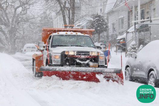
“When precipitation begins, our salt spreading operation will already be well underway, and we won’t stop until the City is safe and clear. We ask all New Yorkers to exercise caution and to give our plows and spreaders the space to do their critical work. It may have been 700 days since the last real snow hit the City, but we are more ready than ever,” said Jessica Tisch, Commissioner, NYC Department of Sanitation.
NYC Emergency Management has proactively activated the City’s Winter Weather Emergency Plan in response to the forecasted conditions. This includes conducting coordination calls with the National Weather Service and city and state agencies and utility partners, and bolstering staffing at the Emergency Operations Center, which is already operational due to the city’s ongoing asylum seeker operations. The administration announced that Alternate Side Parking Regulations will be suspended tomorrow, Tuesday, January 16, 2024. Payment at parking meters will remain in effect throughout the city
As part of the Winter Weather Emergency Plan, the NYC Department of Sanitation (DSNY) has issued a Snow Alert and is fully prepared with a fleet of 700 spreaders. During a Snow Alert, the Department collaborates closely with NYC Emergency Management and the Department of Transportation to implement snow clearing protocols, adhering to the detailed snow plans established by each agency. Based on the anticipated weather, between 20 million pounds of salt could potentially be deployed to manage the snow and ice conditions effectively. DSNY will be tracking operations via its new Bladerunner 2.0 platform, allowing real-time adjustments as conditions require. Every street is on a route and, for the first time, every route can be dispatched at the same time.
NYC Department of Homeless Services is under an Enhanced Code Blue, conducting outreach every 2 hours between 8 p.m. and 8 a.m. No one who is homeless and seeking shelter in New York City during a Code Blue will be denied. Should you see an individual who appears to be homeless and in need out in the cold, please call 311 and an outreach team will be dispatched to offer assistance.
Residential building owners are legally required to maintain indoor temperatures at 68 degrees when the temperatures fall below 55 degrees outside during the day and a minimum of 62 degrees indoors overnight, regardless of outdoor temperatures. If an apartment lacks appropriate heat, a tenant should first attempt to notify the building owner, managing agent or superintendent. If heat is not restored, the tenant should register an official complaint via 311. Tenants can call 311, visit 311 online at NYC.gov/311, or use the 311 mobile app (on Android and iOS devices) to file a complaint. Hearing-impaired tenants can register complaints via a Touchtone Device for the Deaf TDD at (212) 504-4115.